2 - com_geommunity3js setting up
There 3 different places/pages for settings for you to be ready with Geommunity3:
Right after installation, you are encouraged to visit the component parameters options clicking the big green button.
You can access that parameters page later from:

ItemIds: These are menu item ID for pages in Joomla. They are used by Joomla to know what modules to display on what pages and to buil SEF urls. TO find out what ItemID you must set in these fields, find the related menu Items in your menu items manager and write down their ID. Geommunity will use these to build correct links url from infowindows data to user profiles and other integrated Jomsocial content.
Fontello Icons: If your Joomla template doesn't include all the necessary icons for Geommunity3, you can enable this so Geommunity3 will add the missing icons.
Non loggedin users will be prompt by their browser to share location to center the map and if refused default map coordinates will be used.
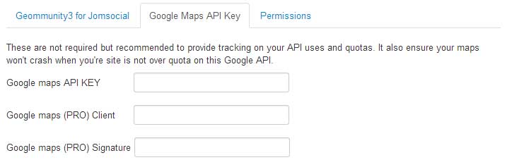
Google Maps API key, client ID and Signature: Although these are not required, they are recommended for production sites, especially those with High traffic to be able to manage API quota limitations etc...
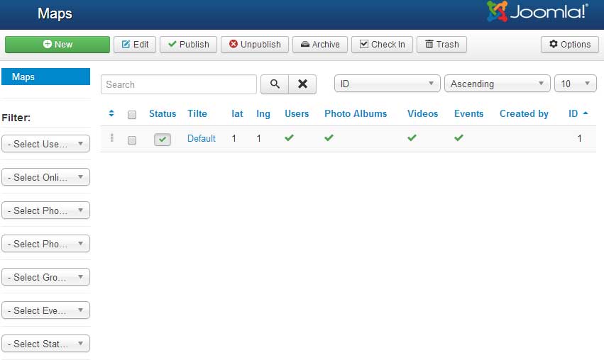
After these parameters set, you now have to set your first map. The installation script created it for you, you only have to edit the settings.
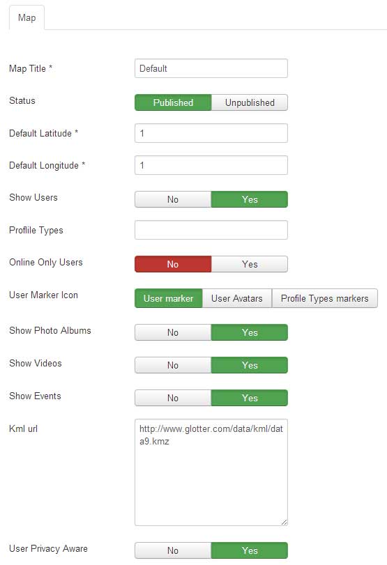
Map Title: Easy !
Status: Published or not
Default Coordinates: This is required to center the map when loading the page in case the map is public and visitor refused to share location with the browser, or in case the logged In user does not have coordinates
Show Users: Show users or not on the map.
Users Addressfield: This field wil help the component where to get users coordinates to plot them on the map. If you don't fill it in the Geommunity could find it by itself but it is especially required if users have more than one addressfield in profile (personal address + pro address for instance) to let Geommunity know what coordinates to be used to locate the user.
Online Only: Only show users currently having an active session on your site
User Marker Icon: You can choose to use the Generic user Marker Icon, or users avatars or also to use different marker icons according to profiletypes ID.
In this last case, you must set png icons in images/com_geommunity3es/profiletypes_markers/ and make sure each marker is named 1.png, 2.png where the value is the profile type ID.
Show Photo Albums, Videos: These alse require you use the provided Jomsocial media admin batch geocoder module
Show Events
KML: Keyhole Markup Language, these are external .kml (xml type) files allowing you to embed additional data on the map. You can add as many files as you want , separating each file url with coma(no space)
User Privacy: Respect privacy set by users on their Geolocator profile application and to their medias ( photo albums, videos).
- Geommunity3js component parameters
- Geommunity3js component Maps manager -> Map settings
- Geommunity3js module settings
Right after installation, you are encouraged to visit the component parameters options clicking the big green button.
You can access that parameters page later from:
- Backend Top Menu -> Components -> Geommunity3 For Jomsocial -> Parameters (top right button)
- Backend Top Menu -> System -> Global Configuration -> Geommunity3 For Jomsocial (on the left column menu)
ItemIds: These are menu item ID for pages in Joomla. They are used by Joomla to know what modules to display on what pages and to buil SEF urls. TO find out what ItemID you must set in these fields, find the related menu Items in your menu items manager and write down their ID. Geommunity will use these to build correct links url from infowindows data to user profiles and other integrated Jomsocial content.
Fontello Icons: If your Joomla template doesn't include all the necessary icons for Geommunity3, you can enable this so Geommunity3 will add the missing icons.
Non loggedin users will be prompt by their browser to share location to center the map and if refused default map coordinates will be used.
Google Maps API key, client ID and Signature: Although these are not required, they are recommended for production sites, especially those with High traffic to be able to manage API quota limitations etc...
After these parameters set, you now have to set your first map. The installation script created it for you, you only have to edit the settings.
Map Title: Easy !
Status: Published or not
Default Coordinates: This is required to center the map when loading the page in case the map is public and visitor refused to share location with the browser, or in case the logged In user does not have coordinates
Show Users: Show users or not on the map.
Users Addressfield: This field wil help the component where to get users coordinates to plot them on the map. If you don't fill it in the Geommunity could find it by itself but it is especially required if users have more than one addressfield in profile (personal address + pro address for instance) to let Geommunity know what coordinates to be used to locate the user.
Online Only: Only show users currently having an active session on your site
User Marker Icon: You can choose to use the Generic user Marker Icon, or users avatars or also to use different marker icons according to profiletypes ID.
In this last case, you must set png icons in images/com_geommunity3es/profiletypes_markers/ and make sure each marker is named 1.png, 2.png where the value is the profile type ID.
Show Photo Albums, Videos: These alse require you use the provided Jomsocial media admin batch geocoder module
Show Events
KML: Keyhole Markup Language, these are external .kml (xml type) files allowing you to embed additional data on the map. You can add as many files as you want , separating each file url with coma(no space)
User Privacy: Respect privacy set by users on their Geolocator profile application and to their medias ( photo albums, videos).
- Created on .
- Last updated on .